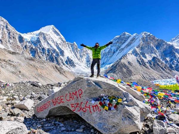
Every route on this map starts at Lukla (2,860 m) and climbs one shared trail through Namche Bazaar to Lobuche. From there they split. The classic route continues up beside the Khumbu Glacier to Gorak Shep and Everest Base Camp. The Gokyo circuit turns west over Cho La Pass into the Gokyo valley and comes back to Namche down a different valley. A helicopter return leaves the trail at Gorak Shep, or at Gokyo if you are on the Gokyo circuit.
Where Does the Everest Base Camp Trek Start and Finish?
The trek starts and finishes at Lukla, a mountain village with an airstrip, Tenzing-Hillary Airport, and no road to Kathmandu. You fly in from Kathmandu or, in the busiest weeks of spring and autumn, from Manthali Airport in Ramechhap, about four to five hours' drive from Kathmandu.
All three routes on this map end in Lukla. You either walk back to it or fly to it by helicopter, and then take a plane to Kathmandu. We also run a version of the trek via Salleri, which is not shown here.
Classic EBC Route Map
The classic route follows three valleys in turn: the Dudh Koshi to Namche, the Imja to Dingboche and the Khumbu to base camp.
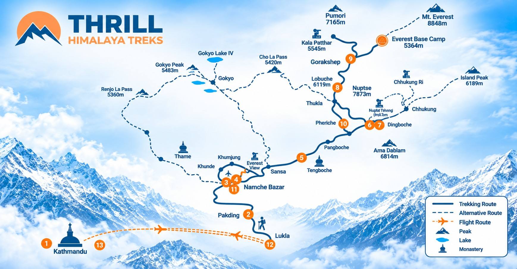
- Lukla to Namche Bazaar. The trail follows the Dudh Koshi river north, crossing it several times on suspension bridges, and enters Sagarmatha National Park at Monjo. After the high Hillary Bridge it climbs steeply to Namche Bazaar (3,440 m), the junction for every route on this map.
- Namche to Tengboche. The path contours above the river, drops to it at Phunki Thenga and climbs through forest to Tengboche Monastery (3,860 m).
- Into the Imja valley. Beyond Pangboche the trees thin out and the trail climbs into the Imja valley to Dingboche (4,410 m), below Ama Dablam and Lhotse.
- Into the Khumbu valley. From Dingboche you cross a wide valley to Thukla, climb the moraine to a ridge of climbers' memorials, and follow the Khumbu Glacier to Lobuche (4,940 m).
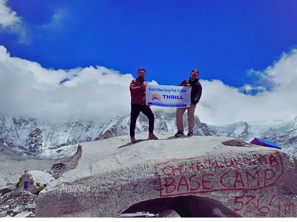
- Gorak Shep and the dead end. Gorak Shep (5,164 m) is the last settlement with lodges. Everest Base Camp (5,364 m) is a return walk from there along the glacier, and Kala Patthar (5,545 m) rises directly above Gorak Shep. Trekkers don't sleep at base camp; there are no lodges there.
On many maps you will also see Pheriche, in a parallel valley just below Dingboche. Classic itineraries often come down that way on the walk out.
EBC–Gokyo Route via Cho La
The Gokyo circuit leaves the classic trail just below Lobuche and returns to it near Namche. On our itinerary you go to base camp first, then cross Cho La from east to west.
- Lobuche to Dzongla. After Kala Patthar, you walk back down the moraine towards Lobuche and turn west onto a smaller trail to Dzongla (4,830 m), below Cholatse.
- Cho La Pass. From Dzongla the trail climbs to the pass at 5,420 m, crossing a short glacier near the top, then drops steeply down the loose western side to Thangnak (4,700 m), also spelt Dragnag.
- Across the Ngozumpa Glacier. From Thangnak a marked trail crosses the rubble-covered Ngozumpa Glacier, and its exact line changes from season to season. On the far side you reach the second Gokyo lake and then Gokyo (4,750 m), on the shore of the third lake, Dudh Pokhari. Gokyo Ri (5,357 m) rises above the village, and the fourth and fifth lakes lie further north up the valley.
- Down the Gokyo valley. The return follows the western branch of the Dudh Koshi through Machhermo (4,470 m), Dole and Phortse Thanga, then climbs to the Mong La ridge and contours back to the main trail near Kyangjuma, just above Namche.
Because the route is a loop, you walk only a few sections twice: Lukla to Namche, the stretch from Gorak Shep back towards Lobuche, and the last part of the walk into Namche.
If snow or ice closes Cho La, there is a longer way round to Gokyo through the village of Phortse that avoids the pass. It adds days, so it is a fallback rather than part of the standard itinerary.
Where Does the Helicopter Return Leave the Walking Route?
The helicopter exit on our Everest Base Camp Trek with Heli Return is Gorak Shep. After the Kala Patthar sunrise on Day 11, you return to Gorak Shep for breakfast and take a shared helicopter to Lukla. You fly from Lukla to Kathmandu the next day.
On the Everest Base Camp with Gokyo Lake Trek, the helicopter is an option rather than part of the plan. If you book it, Gokyo becomes your exit: after the Gokyo Ri sunrise on Day 13 you fly back to Kathmandu via Lukla, instead of walking three days down the Gokyo valley.
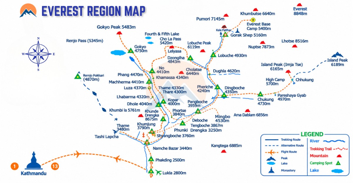
The dotted lines on the map show where the walking ends, not the path the helicopter flies. Helicopters fly only when visibility is safe, usually in the morning.
How Do Sleeping Altitudes Differ From Daily High Points?
On our 17-day loop you never sleep higher than Gorak Shep at 5,164 m. On four days you climb well above the place you slept the night before: about 420 m to base camp, 380 m up Kala Patthar, 590 m to Cho La and 600 m up Gokyo Ri.
Overnight altitudes and high points from our EBC with Gokyo Lake itinerary (17 days), checked 10 Nov 2026
That pattern follows a basic principle of acclimatisation: gain height gradually, add rest nights as you go higher, and climb the big viewpoints from lower beds. It is also why a map that marks only the highest point of each day can make a route look harder or easier than it is. No itinerary removes the risk of altitude illness, so tell your guide at once about headache, nausea or unusual tiredness.
The heli-return trip follows the same profile as far as Gorak Shep, one day later because of its extra day in Kathmandu, and then flies down after Kala Patthar.
Why Do Maps Show Different Altitudes?
Maps and websites disagree on altitudes because they use different surveys, GPS readings and rounding, and because a figure can mark a village, a particular lodge or the highest rock nearby. These are the figures we use, with the others you are likely to see.
|
Place |
Figure on our itineraries |
Other figures in print |
|
Lukla |
2,860 m |
2,840 m |
|
Dingboche |
4,410 m |
4,360 m, 4,440 m |
|
Lobuche |
4,940 m |
4,910 m, 4,930 m |
|
Gorak Shep |
5,164 m |
5,140 m to 5,170 m |
|
Kala Patthar |
5,545 m |
5,550 m, 5,555 m, 5,600 m, 5,644 m |
|
Cho La Pass |
5,420 m |
5,330 m to 5,380 m |
|
Gokyo |
4,750 m |
4,790 m |
Kala Patthar has the widest spread for a specific reason. It is a minor top on the south ridge of Pumori, and most trekking maps give 5,545 to 5,555 m; we use 5,545 m. A GPS reading at the flag-covered summit recorded about 5,644 m, and there is a lower top on the same ridge at about 5,545 m. A map printing 5,644 m is describing the higher point.
Most other differences are 30 to 50 m. Pick one source, use it consistently, and don't worry when a lodge sign disagrees.
Printed and Offline Maps
Printed 1:50,000 trekking maps of the Everest region cover all three routes on this page, including Gokyo and Cho La. Offline phone maps based on OpenStreetMap also show the trail network. Your guide handles navigation, but a map lets you follow each day, see what is coming, and name the peaks around you.
Everest Base Camp Trek Map: Common Questions
Where does the Gokyo trail split from the Everest Base Camp trail?
In two places. On our loop, which goes to base camp first, it leaves just below Lobuche, heading west to Dzongla and Cho La. If you trek to Gokyo first, the split is near Kyangjuma above Namche, where the Gokyo trail climbs to the Mong La ridge.
Is Gorak Shep the same as Everest Base Camp?
No. Gorak Shep (5,164 m) is the last settlement with lodges, and you sleep there. Everest Base Camp (5,364 m) lies further along the Khumbu Glacier; you walk there and back on the day you arrive at Gorak Shep.
If you're deciding between the routes on this map, tell us which one you're considering and how many days you have. We'll send you the current itinerary for it. For how far you walk on each route, see our guide to the Everest Base Camp trek distance.
Explore all Thrill Himalaya trekking packages
- Annapurna Base Camp with Mardi Himal Trek
- Annapurna Base Camp Trek - 10 Days
- Annapurna Base Camp Trek
- 6-Day Annapurna Base Camp Trek for Beginners
- Annapurna Base Camp Trek for Seniors
- Annapurna Base Camp Trek with Family and Kids
- Annapurna Circuit Trek
- Everest Base Camp Helicopter Tour
- Everest Base Camp Trek
- Everest Base Camp Trek via Salleri
- Everest Base Camp Trek with Heli Return
- Everest Base Camp Trek with Island Peak Climbing
- Everest Base Camp with Gokyo Lake Trek
- Everest Three Passes Trek
- Ghorepani Poon Hill Trek
- Gokyo Lake Trek
- Island Peak Climbing
- Manaslu Circuit Family Trek
- Manaslu Circuit Trek
- Manaslu Circuit Trek with Tsum Valley
- Mardi Himal Trek
- Mera Peak Climbing
- Pikey Peak Trek
- Short Annapurna Base Camp Trek -- 5 Days
- Short Annapurna Base Camp Trek -- 7 Days
- Short Manaslu Circuit Trek
- Tsum Valley Trek
Related travel and trekking blogs
- 7 Off-the-Beaten Treks in Nepal
- Annapurna Base Camp Trek Difficulty
- Best Time for Manaslu Circuit Trek
- Best Time to Trek in Nepal
- Best Treks in Nepal
- Manaslu Circuit Trek Complete Guide
- Dashain Tika Time 2026
- Everest Base Camp Trek in November
- How Difficult Is Manaslu Circuit Trek?
- How Do I Prepare for a Trek to Everest Base Camp?
- Manaslu Circuit Trek Duration
- Manaslu Circuit Trek Permits
- Mount Everest Guide
- Is Nepal Safe After Flood?
- Langtang Valley Trek Distance
- Manaslu Circuit Trek: 14 Days Complete Itinerary from Kathmandu
- Manaslu Circuit Trek After Budhi Gandaki Flood
- Manaslu Circuit Trek Guide, Cost, Itinerary and Difficulty
- Manaslu Circuit Trek Nepal: Route, Highlights and Tips
- Manaslu Circuit Trek Guide
- Mount Everest Guide
- Nepal Premier League Cricket Travel Guide
- Nepal Travel Tips
- Tihar Festival in Nepal